
“It’s not just for bicycles. It’s for pedestrians, families with small children, all sorts of nonmotorized transportation. It’s wide—wider than a bike lane and it’s a natural spine through Ann Arbor that’s perfect for a greenway,” Cynthia VanRenterghem, the Executive Director for Development at The Treeline, said. “It’s on a floodplain, surrounded by trees and there’s so much potential for a really beautiful, and also highly usable, safe and accessible manner to get through the key parts of the city, and to our river, in a way that doesn’t require a car and isn’t competing with commercial or residential development because it isn’t buildable. It’s just sitting there waiting to become an amazing asset for the city.”
The proposal is similar to The High Line in New York, or Paris’ Coulée verte René-Dumont. If completed, what they are proposing would be a public space that would be equal parts public park, jogging trail, bike lane and a community space.
Organizers envision a three-mile trail lined with native trees, flowers, rain gardens, and beehives, where families can play and commuters can travel by bike, scooter, or skateboard safely through the heart of Ann Arbor, free from traffic and cars.
“It opens the city, the downtown, to the river… This really increases access [to] that from the downtown, as well as from the Athletic Campus and the University of Michigan’s student housing,” Norman Herbert said when asked about the motivation behind The Treeline. A former Treasurer for the University of Michigan, now director and co-chair of the Treeline Conservancy.
Herbert added, “there’s discussion of introducing the Treeline as a pollinator corridor … because we want to get rid of invasive species and plant pollinating plants that will enhance the environment.”
The Ann Arbor Railway is now owned by Watco, a Kansas-based company.
“There have been various conversations between The Treeline Conservancy and the Ann Arbor Railroad for a number of years. We appreciate Treeline’s outreach on this project and their desire to involve the railroad early in the process,” Watco spokeswoman Tracie VanBecelaere said in an email.
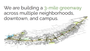
What the Treeline can look like
McCullough said that she worked on a similar project, the Waterloo Trail in Austin, which followed a creek to the east of the downtown of Texas’ state capitol. And in a way, so does The Treeline.
The Treeline will be following the course of Allen Creek. This subterranean creek runs more or less along the rail line and has shifted its course significantly in the face of human development. Building anything other than a trail like this on the land the Treeline Conservancy has selected is technically possible, but it would be extremely difficult and expensive according to Brett Lenert, the planning manager for the city of Ann Arbor.
“Our zoning and codes permit some construction of residential in flood fringe areas (these are areas where in the event of a significant water event water could be present). In these circumstances, buildings would need to be constructed to the appropriate standards to account for this potential (i.e. raised elevations, designed to allow ebb and flow of stormwater, etc.). In cases where there is a designated floodway (areas where in a storm event that water is expected to be under current or flowing) housing is not permissible,” Lenart said over email. When asked about the potential impact to the cost of housing, Lenart said “I don’t think that the Treeline would be a significant concern to housing limitation, and in fact, that type of infrastructure can support higher density development.”
Storm water and snow melt are only going to get more and more intense as climate change worsens since the more carbon dioxide that is emitted by cars, mines and factories, the more heat gets trapped in the atmosphere, causing wild swings in weather. The atmosphere had 368.63 parts per million of carbon in it at the turn of the twenty-first century, which then climbed to 422.8 parts per million by 2024, according to the National Oceanic and Atmospheric Administration. McCullough points out that linear parks like the Treeline could be like a sponge for Ann Arbor, naturally taking up a lot of that extra water and distributing it throughout the urban ecosystem more safely.
The Great Lakes Integrated Sciences and Assessment—a collaboration between the U of M, Michigan State University and NOAA—which studies the effects of climate change on the Great Lakes region to provide accurate scientific information to policy makers—has found that in comparing the amount of rainfall that the region saw from 1991 to 2020 was 15 percent higher than 1951-1980. The city received 45.86 inches of precipitation in 2000, 35.09 inches in 2005, 38.88 inches in 2010, 34.97 inches in 2015, 38.41 inches in 2020, and 42.13 inches of precipitation last year, according to data provided by GLISA’s Omar Gates, a climatologist specializing in combining climate data with Native American knowledge about climate adaptation and in using data to adapt to changing conditions.
Completion of this project would also represent a landmark piece of non-motorized transportation infrastructure as well. Cars still provided the lion’s share of 69.18% of American commutes in 2023, the latest year for which figures are available from the Bureau of Transit Statistics. That is much lower than in previous years since 13.84% of respondents worked at home, and it is important to note that 8.99% of trips reported carpooling and another 1.54% of trips took place on motorcycles or on taxis or taxi equivalents. About 3.53% of Americans used public transportation – but 2.44% walked and 0.470% of Americans bicycled. How many more would walk or bike to work with a linear park running through the spine of Ann Arbor?
Where the Treeline currently stands
Just like the Border to Border Trail, The Treeline is building its project in sections with the easiest sections being completed first, resulting in a patchy pattern of development that they hope will get more and more filled in as time moves on. See a map of the proposed Treeline on The Treeline’s website.
RELATED: Broadway Park West Opens: Ann Arbor’s Newest Riverfront Destination
Starting from the southern end, the first section is Wolverine Way, which has already begun construction according to The Treeline. It starts at E Madison St. and stretches past the new U of M dorms. It will eventually connect to S State St. and the athletic campus.
The central part of the plan is called the Neighborhood, which is mostly in a design and engineering stage; although parts of it have been completed. It would start along the western side of the train line from Madison Street to Liberty, then it will continue north by the YMCA. Once it crosses Huron Street, it will go to a T-junction providing users a choice of either zipping over to West Park, or to go along the main line to the east side of the railway, continuing northwards to Felch Street.
Some of the Neighborhood section includes an existing bike lane. The biking enthusiast publication People For Bikes ranked the half-mile-long two way bike lane along the eastern side of First Street as the seventh best of their list of new bike rails of 2020.
The next potential part of the route could go past a recently demolished former industrial building just west of the WATCO tracks at 415 West Washington Street. Planning for a “pocket park” to be part of the Treeline west of the north-to-west train line at 410 Miller Avenue, started in 2022.
The northernmost part of the project is called The Gateway, and it is mostly in the design and planning stage, says The Treeline. M-Dot completed a pathway under the east-to-west railroad called the $9.4 million Allen Creek Berm Tunnel in 2020; to provide both pedestrian access and to mitigate the Huron’s regular flooding. This cut under the east-to-west railroad tracks will be key to making The Treeline realistic. The Wolverine, the passenger service which goes from Pontiac to Chicago, uses the east-to-west train line that serves Kerrytown Station.
How it will be funded
The Treeline has been a long time coming—originally starting as opposition to development near the Huron River in 2000. With the help of local developer Joe O’Neal, they became a 501©3 non-profit in 2007 and started hiring full time staff in 2020. The Treeline has been a regular feature in city council meetings and feasibility studies since then. Funding from the City of Ann Arbor and private donors has since started coming in, as well as a donation of land from a local who came on board. The pandemic proved only to be a temporary break from their progress.
The Treeline estimates that $2.8 million will be necessary to get the project done. The State of Michigan appropriated $1 million in the fiscal year 2025 budget to The Treeline.
Funding for the project comes from the Bank of Ann Arbor, Huck Finch, O’Neal Construction, the Washtenaw Dairy, Sic Transit Cycles and Zingerman’s, among others, according to the Treeline Conservancy. They also accept public donations on their website. And after the linear park is completed, Herbert said they have a plan to make sure that it stays a safe and welcoming place without costing Ann Arbor taxpayers once it becomes a city asset upon completion.
Herbert explained that the City of Ann Arbor’s Department of Parks and Recreation has been very clear with them that under the current budget and taxation conditions “they cannot take on additional maintained liability, so our intent is to create an endowment to ensure that it will not add to the liability for maintaining a greenway.”
The Treeline does not elaborate in its yearly statements nor on its website on just how much money they got from each of their corporate sponsors.
“Done right, they should invest in quality space, quality design, quality infrastructure. And I don’t think we should be afraid to invest significant money in this space. This could be the jewel of the city. My concern is, because it will be so expensive, that Ann Arbor will reach for the bare minimum and make it a shared use path rather than thinking of this as a really important public space… What I really like about the Treeline Trail is that it’s an opportunity to connect the city to the river…. ,” Professor Kit McCullough, who teaches architecture, land use planning and urban design at the U of M, explained. She added that she has had students who had never even seen the Huron. “I would like to see significant investment in quality park space. This isn’t just a hike and bike trail. It really should be the premier public park space within the city. The renderings on the website have that ambition and so I am really glad that they’re seeing this as a series of really great spaces; with design and investment and landscaping, and all of the potential that can be there; but that’s going to be very expensive.”
Potential issues and solutions
McCullough said that projects like these tend to succeed or fail depending on how well thought out the plan is and how it integrates with the neighborhoods that it bisects.
“My concern is that the City will treat it as a glorified bike path and I think that that would really limit its possibilities and impact, that it should be much more than transportation. It really should be thought of as park space. If you think of the successful ones like the High Line or the Beltline in Atlanta, their success comes from being so much more than transportation corridors. They’re also activity spaces, park spaces,” McCullough said.
She added “The heart of building the Treeline Trail is not building the trail itself, but planning the adjacent parcels, and this is something I think that the High Line in New York also failed to do. So, we should think about how the trail interacts with the adjacent parcels in terms of zoning. This should be integrated into the comprehensive land use plan conservation and thinking about how adjacent parcels contribute to the Treeline Trail and vice versa. The other thing is capturing the tax value. Some of that financing might go towards preserving affordability adjacent to the trail through community land trusts or housing affordability funds. It’s something that the Beltline in Atlanta did well – thinking about how the adjacent parcels connect to it. Similarly, the Beltline really activated parts of the city, so it becomes this very active space, and I am a little concerned that the Treeline Trail—going behind buildings, and people’s back yards—instead of being a front yard for everybody—which is how Atlanta thought of the Beltline—and how we should think of it.”
The Treeline told Current that they are actively doing the latter.
“In some respects the existence and utility of a trail is self-evident. But also the City and Conservancy has been talking about the Treeline Trail for years now; incorporating it into plans, discussing it periodically at Council,” Mayor Chris Taylor said. “I think that the opportunity and existence of neighborhood engagement has been consistent and thorough.”
Safety is top of mind in the designing process, and The Treeline Conservancy is planning appropriate barriers to keep children and pets away from the tracks. Concerns about this are being addressed with public art and as The Treeline pointed out, a properly crafted linear park would be a much safer route for children on bikes and adults choosing to swap their car to commute to work by bicycle then a wide avenue filled with cars like Miller, Huron, Main Street or Packard Road.
“Safety is at the center of everything the Ann Arbor Railroad does. In our day-to-day operations, our review of potential projects, and our interactions with the community, each conversation starts with safety. This is why, for example, we were pleased to host the kickoff event to this year’s See Tracks Think Train week in Ann Arbor, and why we take U of M’s home football schedule into consideration when operating each fall,” said VanBecelaere. “While there has been a dramatic decrease in train/motor vehicle collisions since they peaked in 1972, recent years have seen a slight uptick in both incidents at grade crossings and those involving pedestrians on rail lines. Operation Lifesaver has active chapters in Michigan and across the country to educate the public about safety along rail lines. They provide guidance for pedestrian safety on their website at oli.org/safety-near-trains/walking-safely-near-tracks.”
Future plans
The biggest hurdle in the eyes of VanRenterghem and Herbet will be to connect the Treeline to the river across the intersection of Main Street and Depot Street to the river they are aiming towards in The Gateway section. VanRenterghem predicted that this final section could be completed by 2030.
They are proposing the pedestrian bridge “spanning North Main Street” to avoid cutting through people’s yards in northern Kerrytown, and to ensure that bikers and pedestrians don’t have to navigate the omni-present heavy traffic of commuters going between downtown, M-14, and to the hospital. Detroit-based architectural firm INFORM Studio was brought on in 2023 to design that bridge. The current plan is for that pedestrian bridge to go over the north-to-south track.
According to a map from The Treeline Conservancy, the proposed pedestrian bridge is intended to elevate “over Depot and Summit Streets and includes a signature bridge spanning North Main Street. The Gateway segment continues a grade level through the city’s maintenance yard and ends at Felch Street” which would connect with the middle section, The Neighborhood.
The eventual goal is to connect to the Border to Border Trail, which runs near alongside the Argo Cascades. Herbert and VanRenterghem are big fans of that trail, and it is similar in a sense. But realize: the Border to Border Trail is an intercity jogging trail that goes through huge stretches of countryside for most of its length. What they are proposing is an urban version of that, presenting a large number of challenges.
“On the one hand you can say we’ve been working on this for a really long time. But on the other hand, it’s been only in the last few years that so many key things have fallen into place,” VanRenterghem said. “I thought it was pretty prophetic of the people 20 years ago to imagine this vision for the river before the river was any place that anybody would ever want to go. Now it’s become such a destination. And the same thing with Wolverine Way. Once the University started to see their whole plan for their new dorms… suddenly it made a lot of sense to them to have that passageway. But we were talking to them when they didn’t own any of that property. I feel like a lot of times that people are catching up to us, but a lot of things had to fall in place to make it a reality.”
Drew Saunders is a freelance business and environmental journalist who grew up just outside of Ann Arbor. He covers local business developments, embraces his foodie side with reviews restaurants, obsesses over Michigan's environmental state, loves movies, and feels spoiled by the music he gets to review for Ann Arbor!